How is the current SOBN network defined
In 2014 the State Observation Bore Network (SOBN) was reviewed to be representative of the hydrogeology and pressures on groundwater systems across Victoria.
Monitoring bores from each groundwater catchment were selected for the current SOBN. We used these criteria:
- At least one bore in each Victorian aquifer framework (VAF) aquifer, each hydrogeological zone (catchment system) in each groundwater catchment across Victoria.
- At least one bore in each intensive management area (Groundwater Management Area/Water Supply Protection Area)
- One representative bore within groundwater zones (catchment systems) having similar groundwater trends.
- In each aquifer of the shallow and deep basins, three bores to allow for the determination of gross flow direction
- At least one nested bore for monitoring inter-aquifer transfer.
The spatial distribution of SOBN provides a baseline assessment of resource condition and trends assessment for modelling and strategic planning.
The criteria do not specifically cover other important hydrogeological considerations of our partners such as:
- groundwater-surface water interaction studies (i.e. gaining/losing sections)
- groundwater dependant ecosystems (GDEs)
- groundwater quality monitoring (saline intrusion or dryland salinity monitoring
- Monitoring specific to high extraction zones or licence conditions (i.e. trigger bores)
SOBN is still used by the Regional Water Monitoring Partnership (RWMP) for these purposes, along with other monitoring sources.
Partners within the RWMP may also add other monitoring bores.
What is SOBN trying to represent?
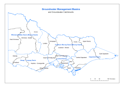
A groundwater catchment is an area containing a connected groundwater resource, bringing together the input (recharge) areas, use areas and discharge areas. A groundwater basin comprises one or more groundwater catchments within a geological basin. In some cases, a basin may be broken into one or more sub-basins to reflect administrative boundaries.
There are 5 groundwater Basins, and 20 groundwater catchments defined in Victoria.
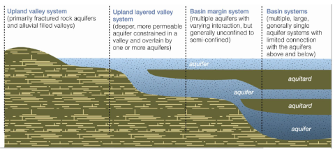
A groundwater system begins where water enters an aquifer (recharge) and ends at its point of exit (discharge). It may include a single aquifer, a group of connected aquifers, or groundwater and surface water elements in conjunction. Groundwater systems can be simple or complex. Smaller, simpler aquifers are common in upland areas. In lowland areas, systems may be larger and more complex. DEECA's groundwater management framework has subdivided the aquifer system across the state into four systems:
- Upland Valley,
- Upland Layered Valley,
- Basin Margin
- Basin
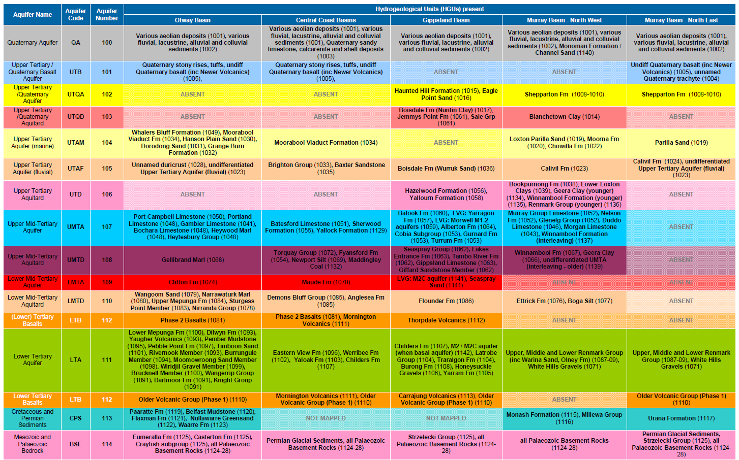
15 aquifers are defined under the VAF based on stratigraphic correlation. These aquifers, which comprise both water bearing and water isolating geologies may contain multiple geological units. A summary of the hydrological units, - geologies that represent each aquifer in an individual groundwater basin is provided for reference.
Reviewed 11 June 2024