On this page:
Download data
Tailored site metadata
Site metadata can be downloaded from the 'table' view (as opposed to the map view) of the 'explore data' page.
After site selection, the user can tailor the site metadata that they would like to download.
Surface water metadata
Site metadata for surface water includes:
Default column headers:
- site ID
- site name
- river basin
- active
- site parameters
Other options include:
- CMA
- catchment area (upstream catchment)
- data type
- telemetered type
- control
- cease to flow level
- map zone
- elevation
- zero gauge
- max gauged level
- max gauged date
- Easting
- Northing
- grid datum
- latitude
- longitude
- lat/long datum
- commence
- cease
Groundwater metadata
Site metadata for groundwater includes:
Default column headers:
- site ID
- site name
- active
- site parameters
- site type
- surveyed elevation
- year construction date
- aquifer (VAF)
- GMU
- bore depth
- screened from
- screened to
- headworks height
Other options include:
- CMA
- data type
- telemetered type
- map zone
- Easting
- Northing
- grid datum
- latitude
- longitude
- lat/long datum
- commence
- cease
The user can change the order of column headers to suit their downloading needs. Detailed guidance can be found at How to use WMIS.
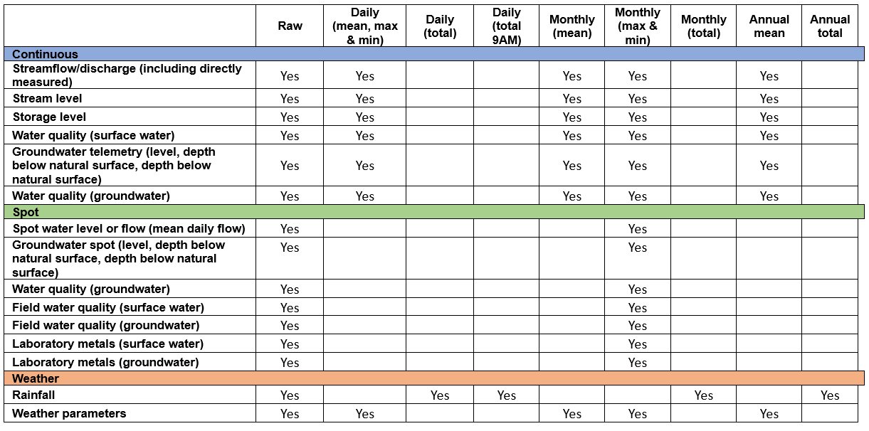
Parameter resolution
Parameters can be downloaded as raw data, as well as other resolutions up to annual mean, and annual total.
Continuous data has resolution options of:
- raw, daily (mean, max & min)
- monthly (mean)
- monthly (max & min)
- annual mean.
Spot data has resolution options of:
- raw
- monthly (max & min).
Rainfall data has resolution options of:
- raw, daily (total)
- daily (total 9AM)
- monthly (total)
- annual total.
Weather parameters data has resolution options of:
- raw
- daily (mean, max & min)
- monthly (mean)
- monthly (max & min)
- annual mean.
The below image summarises the various resolution options available.
Download everything
Should you need to download everything, we have a weekly update of all data. You can download the lot using this zip .
Reviewed 02 July 2024