
Control structures and weirs
Introduction to controls
Controls are physical barriers across waterways used in determining stage-discharge relationships. They constrict flows through a single low point in the waterway, which helps recording changes in water level and flow. The term 'control' refers to barriers of all kinds - weirs, flumes, fish ladders or natural bedrock.
We use the two-dimensional shape of the control, known as a 'cross section' as a key component in calculating flow. Hydrographers calculate discharge, or flow, by multiplying area by velocity. The control cross section at a known water level provides a horizontal area, and gaugings provide the velocity data. Over time, we use water level, control shape, local river characteristics and many gaugings to develop a rating curve for the site.
We try to install our measuring sites upstream of controls in the backed-up pool of water they create. These pools help with monitoring low flows and keeping instruments safely away from high velocities in the main channel of a waterway.
Understanding the effects of controls on flow data
There are two key terms that help understanding the effect a control has on a site – stability and sensitivity.
- Stability refers to how the physical shape of the waterway and control change over time. A concrete control in a channel is likely to be more stable than one in a sandy, flood-prone area (e.g. the Snowy River). A site with many rating changes is likely to have an unstable control or bank.
- Sensitivity refers to how changes in water level at a site relate to changes in flow. A sensitive control will see large changes in level for small changes in flow. These are ideal for sites where accurate low flows are critical.
Insensitive controls will see the opposite occur where small changes in level relate to large changes in flow. The sensitivity of a control doesn't always relate to the accuracy of flow data. But it's an important element of understanding how site purpose and characteristics may affect flow data. The sensitivity of a site and shape of control are often represented in the shape of their rating curves.

Controls generally have the most impact on the stage-discharge relationship at low flows. High water levels generally drown the control, and those structures have minimal effects on the stage-discharge relationship. Once a river breaks its banks during a flood event, floodplain cross sections can be kilometres wide.
We try to pick the best possible location to install our monitoring sites, and often weighing data accuracy against environmental effects of an engineered control structure.
The following section describes the types of controls we have in our network and some of their characteristics.
Types of controls
-
Hydrographers inspect the condition of control structures on a routine basis to ensure that they're functioning as expected and are clean of debris. Some control structures are incredibly sensitive to the effects of debris, where even the slightest build-up of algae can change the stage-discharge relationship.
There may be significant changes in water level and flow data immediately after a site visit if the hydrographers have removed a large amount of debris from a control, such as a tree or rocks.
These large changes in water level and flow caused by debris on controls may be present in near-real time unverified data but will be edited out by the hydrographers as part of the quality coding process.
-
Artificial controls have their drawbacks. While increasing low flow accuracy, they can increase sedimentation and disrupt fish migrations.
Water managers are increasingly required to consider fish passage around control structures. If we identify a control as disrupting native fish passage, the site may need a fish friendly alternative.
Fish friendly controls, fish ladders and fish ways, allow fish to migrate upstream and downstream of the site. They are designed to create ideal conditions for native fish movement, including rapids and resting pools.
The following principles are best practice for considering new fish friendly controls:
- should be suitable for all native fish that move through the site.
- should be designed to provide year-round passage for fish over the full range of flows or, as a minimum, ensure passage when fish are migrating.
- should provide both upstream and downstream fish passage.
- should be designed to minimise fish injury.
- Resting habitat should be provided within the fishway
The RWMP works closely with the Arthur Rylah Institute for Environmental Research (ARI) in identifying the sites that pose the largest risk to native species, and to design and install fish friendly controls.
ARI have a range of resources and guidelines on fish way design, construction and performance.
-
While most controls work by restricting the water over a known barrier (in height and width) flumes constrict the waterway horizontally, that is they push more water through a narrow channel without much vertical change in bank height.
As they don’t have the knife edge or crest seen on other types of weirs, flumes can provide greater flow accuracy in a channel, but are susceptible to being less accurate if there are back up effects present.
-
Some of the RWMP sites monitor regulated channels, culverts or pipes. The controls on these sites can be gates, valves, drop-boards or culverts and are often operated by third parties.
The stage-discharge relationships at these sites are often complex and dependent on local operations.
-
Constructing an artificial control isn't always possible, or required, at all sites.
At these sites, it's the natural shape of the waterway that determines the stage-discharge relationship.
We simply refer to these sites as having ‘natural’ controls.
We try to pick the best possible location to install our sites, and often weigh data accuracy against environmental impacts.
-
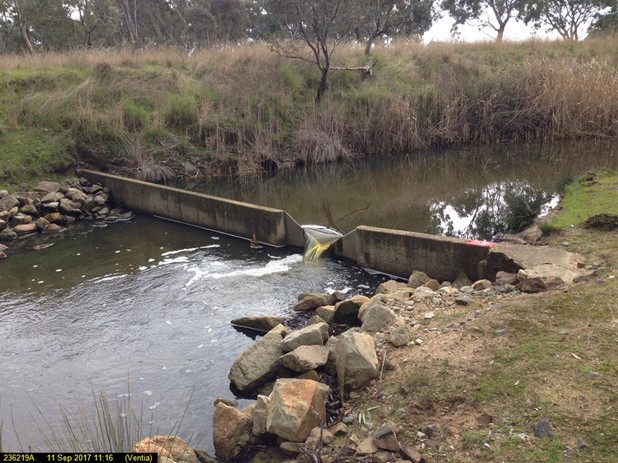
There are a range of weir types across our monitoring network, including varieties such as v-notch weirs, rectangular weir plates, and concrete hump weirs. These all function by having an engineered structure in the waterway with a known height and width, and therefore a known area.
Weirs are designed to provide the optimal hydraulic conditions to develop and maintain a stage-discharge relationship, and are often installed at sites where highly accurate flow data is required.


Reviewed 11 June 2024